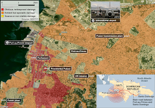
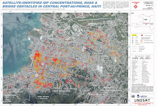
I found the following two maps when searching for good and bad maps for our Cartography course. I was interested to see how satellite imagery was used to assess the extent of damage (in the first map) and to be able to pinpoint physical barriers to providing humanitarian disaster relief (in the second map). The first map would have been useful to pinpoint areas to focus relief efforts upon. And the second map would have been useful to plan the logistics of early relief efforts.
With such awesome technology at the relief agencies fingertips one does rather wonder what went wrong. However, this being the poorest country in the western hemisphere (aided and abetted by the IMF and their ilk I see), I expect the logistical challenges to the relief efforts would be similar to here in Malawi, where we had our own little earthquake hours before the Haiti Earthquake struck. No casualties for that one, although 1000s of people remain homeless in Karonga district after a flurry of earthquakes over the past few months.
No comments:
Post a Comment